Global Site
Breadcrumb navigation
LIDAR, the laser technology used to measure an entire asteroid, survey the moon and support people on Earth
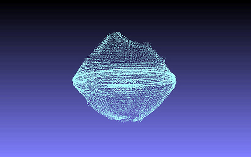 Larger view
©National Astronomical Observatory of Japan (NAOJ), JAXA, Chiba Institute of Technology, University of Aizu, Nihon University, Osaka University
The asteroid Ryugu, which Hayabusa2 explored, is as black as charcoal and unusually shaped, with a bulge in the middle. Tracing its origins and evolution requires precise three-dimensional data. Obtaining such data was also indispensable to Hayabusa2’s operation — including identifying a site for its historic touchdown. Ryugu may be small, but it still measures 900 meters in diameter and has a complex shape. How was it successfully reproduced in 3D?
Hayabusa2’s LIDAR laser altimeter was the key. LIDAR is a device that measures the distance to the surface of, say, an asteroid by projecting a laser beam at it and detecting the returning light. By taking a series of readings like a 3D scanner, it created a 3D model of Ryugu. To size up the entire asteroid, precise measurements had to be taken repeatedly.
This cosmic LIDAR system has its roots in the laser altimeter carried aboard the lunar orbiter Kaguya launched in 2007. Kaguya’s LIDAR system, manufactured by NEC, succeeded in accurately surveying the moon’s heavily cratered surface, which is far more rugged than Earth’s. The information so obtained has been indispensable to subsequent lunar probes.
LIDAR also played a key role in ascertaining where Hayabusa2 was at any particular moment in its flight path (orbit) around the asteroid. Basically, a spacecraft’s orbit is tracked by sending radio waves from Earth, but radio waves have a margin of error of several hundred meters. LIDAR data was therefore used to calculate Hayabusa2’s position. Assuming the explorer was in a particular location, scientists worked out how far the laser light should travel back to it after bouncing off the asteroid. Any deviation in its orbit could then be corrected based on the difference between the estimated distance and the distance actually traveled by the returning light.
LIDAR helped reveal Ryugu’s composition as well. The laser beam emitted by LIDAR is a coherent form of light energy. It travels in a dead-straight line without becoming diffused, even over long distances. Its conditions of brightness are always the same. So by aiming the LIDAR beam at Ryugu’s surface, measurements could be taken of how much light bounced off the rocks — that is, of the rocks’ reflectivity. Differences in reflectivity made it possible to distinguish the different types of rock packed together on the surface. Scientists could then identify the various materials from which Ryugu is agglomerated.
In December 2020, after returning to this planet to release its capsule and setting out on a new journey, Hayabusa2 tested a two-way laser link with Earth using LIDAR. It succeeded in receiving a beam sent from an observatory on the ground and returning the signal. The beam traveled six million kilometers — more than fifteen times the distance between Earth and the moon. Thanks to this technology, it should soon be possible to pinpoint the position of a spacecraft with far greater precision when exploring the uncharted frontiers of space.
Among the major advantages of LIDAR is its ability to produce a 3D scan of an object by measuring its distance. It also detects differences in reflectivity between objects. Both these features have proved invaluable on Earth. LIDAR can be used to make 3D scans of large buildings. It can be used to identify differences in the surface shape and reflectivity of bridges, roads, and other forms of infrastructure. Analyzing variations in such data can reveal subtle changes. You can even determine when substation equipment has been damaged because of a bird nesting there, or when the surface of a bridge or a cliff has started buckling. LIDAR, which has accomplished so much in space, is also helping make us safer here on Earth.
Written by Ayano Akiyama
Published: March 5, 2021