Two-dimensional Small Displacement Analysis Technology Utilizing Satellite Radars Enabling the Deterioration Inspection of Multiple Roads and Buildings in Urban Areas
Featured Technologies
July 20, 2018
Background
There has been a growing need for preventative maintenance to detect critical areas and prevent accidents and problems in advance, as measures to deal with the deterioration of buildings, roads, and other pieces of infrastructure. The implementation of screening inspections is desirable as a low cost primary inspection that can comprehensively cover a wide area for efficient assessment of the condition of a massive number of infrastructure objects in an urban area.
Under these circumstances, small displacement analysis technology using satellite radars (Synthetic Aperture Radars: SAR, Note 1) has been developed and commercialized as a screening inspection method (Note 2). This two-dimensional displacement analysis technology, which uses data from two satellite radars to integrate the analysis results, is anticipated to be a technology which enables precision analysis in both horizontal and vertical directions instead of just analysis in one direction from one satellite radar. However, in areas with a high density of buildings and other objects, it is difficult to determine which structures the radar reflection points hit, which makes the mapping of the reflection points required for integration a difficult problem. When these reflection points are forcibly mapped, the errors in the integrated two-dimensional displacement analysis results become significant in some cases, which makes it difficult to apply as a screening method in urban areas where needs are high.
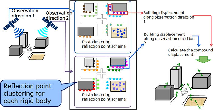
Figure 1: Overview of "two-dimensional small displacement analysis technology".
Features of the new technology
The newly developed "two-dimensional small displacement analysis technology" achieves highly accurate small displacement analysis down to the millimeter order even in urban areas by using NEC's own reflection point clustering technology to map the reflection points. In this method, infrastructure objects are viewed as an aggregation of rigid bodies (ex: concrete mass, etc.), and radar reflection points corresponding to the same rigid body are clustered together to achieve the two-dimensional small displacement analysis for each piece of infrastructure that is required for screening inspections in urban areas. As a result, this makes it possible to detect extremely important forms of displacement from the perspective of structural maintenance such as determining the impact of significant ground settlement on buildings in an area of reclaimed land.
Reflection point clustering enables displacement analysis for each infrastructure object In order to cluster radar reflection points associated with the same rigid body, we use the characteristics of reflection point position and the degree of change similarity. For the same rigid body, the radar reflection points can be expected to be positioned close to each other. Furthermore, because the entire rigid body moves not only in the case where there is serious structural displacement but also due to the impact of weight changes within the structure, it can be expected that the changes in the reflection points on that rigid body also look similar. By clustering the reflection points to satisfy these two characteristics simultaneously, the extracted reflection points are separated and mapped to each rigid body. Figure 2: Reflection point clustering for separating the reflection points corresponding to the rigid bodies
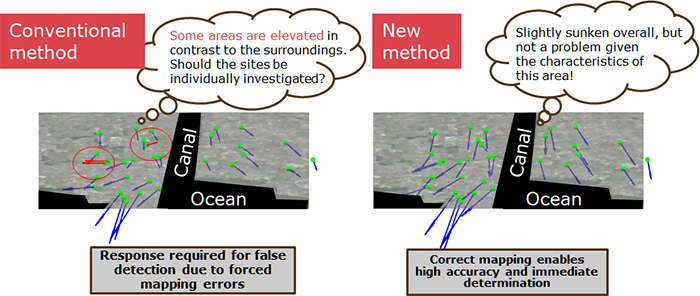
Correct mapping of reflection point clusters based on map information that is suitable for the two-dimensional displacement analysis The shape and position of the reflection point clusters separated by rigid body enable a comparison with map information. The reflection points are mapped to the actual infrastructure objects, which enables the accurate mapping of reflection point analysis results observed from two different directions. Displacement measurement results with very few errors can be obtained from the two-dimensional displacement analysis based on the correct mapping. Figure 3: Two-dimensional displacement analysis using reflection point clustering As a result of evaluating this technology in an area of reclaimed urban land (Figure 4), in the case where reflection points are forcibly mapped using a conventional mapping method developed for mountainous areas, some reflection points appear to be displaced in an upward direction in contrast with the surrounding areas, which means that a review is required to determine whether to perform a detailed inspection for this verification, and the inspection period and cost increase. In contrast, the results of the correct mapping under the new method make it easy to determine that the entire area is sinking uniformly, there is no abnormal displacement, and a detailed investigation is unnecessary, which contributes to keeping the inspection period and costs under control. In addition, as a result of comparing settlement and upheaval of the benchmarks (Note 3) in urban areas, it has been confirmed that errors in regarding manual surveying as correct have been reduced by approximately 40% compared to conventional technologies for mapping mountainous areas. Figure 4: Example of analyzing the displacement of reclaimed urban land through the new method (The dark areas are the ocean, and the light gray areas are reclaimed land. There are two areas of reclaimed land separated by a canal.)
As described above, the improvement in displacement analysis accuracy with this technology increases the reliability of screening inspections and significantly contributes to the streamlining of preventative maintenance for deteriorating urban infrastructure. NEC is advancing the practical application of this technology for use in various areas of displacement analysis including not only the diagnosis of infrastructure deterioration but also the monitoring of ground displacement due to constructions and the monitoring of large-scale plants.
NEC will be announcing its current results at the "IGARSS (International Geoscience and Remote Sensing Symposium)" international conference on remote sensing (Dates: July 22 (Sun.) to July 27 (Fri.), Venue: Valencia, Spain). URL: https://igarss2018.org/
(Note 1)
Synthetic Aperture Radar (SAR): SAR is a technology which obtains high resolution radar images by using the motion of satellites orbiting the earth to substantially increase the size of the radar antenna (aperture). For example, the NEC small radar satellite ASNARO2 can obtain highly detailed images with a resolution of about 1 m from a height of several hundred kilometers above the earth. However, because radar only measures the distance, the radar images which are obtained appear warped when compared to images taken with an optical camera.
(Note 2)
Small displacement analysis technology through SAR: Displacement analysis technology which uses radar images consisting of reflection points (also called scattering points) on structures such as the ground and roads obtained through radar observation of the surface with periodically orbiting radar. Regarding the stable reflection points in dozens of periodically observed radar images as resulting from a single structure and performing a time series analysis enables the small displacement of the ground and roads to be measured at a millimeter level every year. The displacement analysis technology with one satellite is being researched and developed for practical application as the "R&D of the technology which monitors the displacement rate of an artificial structure with high accuracy and efficiency" by an "Infrastructure Maintenance, Renovation and Management" research and development team in the Cabinet Office's Cross-ministerial Strategic Innovation Promotion Program (SIP).
(Note 3)
Benchmarks: Altitude observation points established and managed by the Geospatial Information Authority of Japan or local governments.
※
The information posted on this page is the information at the time of publication.


 https://igarss2018.org/