Global Site
Breadcrumb navigation
The power of 250-meter resolution
One great improvement that SHIKISAI has brought about compared to conventional earth observation satellites is in the resolution at which the earth’s surface is shown. Conventional satellite images show the earth’s surface divided up into 1,000-meter squares. But with SHIKISAI each square is just 250 meters, a considerable improvement. Meaning, any given area can be shown in 16 times greater detail.
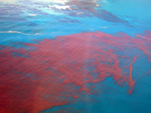
The high precision with which SHIKISAI observes the earth’s surface is particularly valuable for monitoring, say, the occurrence of “red tide”, a serious problem for the fishing industry. Red tide is a phenomenon in which the color of the sea appears to change, due to abnormal phytoplankton breeding, also known as "harmful algal blooms (HABs)". SHIKISAI can detect the color of the sea in detail, and can grasp the situation where red tide is occurring.
The high resolution capability of SHIKISAI is key not only for the wide ocean, but also for land observation. In the summer of 2018, soon after commencing observations, SHIKISAI surveyed the Japanese archipelago during a heatwave that generated headlines, and with its 250-meter resolution it revealed a fascinating fact. In central Tokyo, which was swelteringly hot owing to the heat island effect, places with abundant trees such as Hibiya Park and the Imperial Palace were slightly cooler than the surrounding area. SHIKISAI’s sharp eye even detects how trees cool the ground in densely built-up cities.
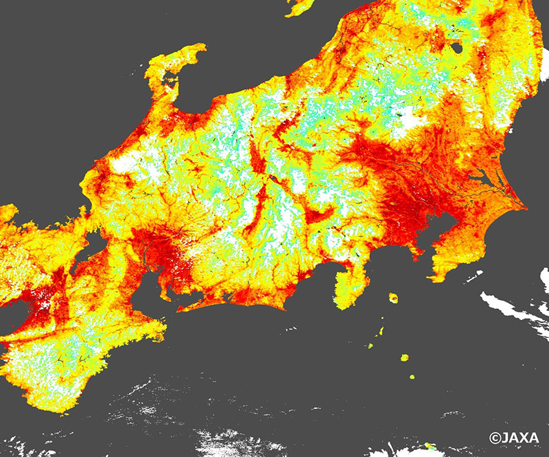
This image showing the intense heat of the Japanese archipelago, taken on August 1, 2018 propelled SHIKISAI to fame. The urban area surrounding Tokyo (middle right in the image) is very hot due to the heat island phenomenon. The city center where the temperature was slightly lower, reveals how the greenery of the Imperial Palace has a cooling effect.
©JAXA
Interview and article by Ayano Akiyama
Published March 30, 2020