Global Site
Breadcrumb navigation
The color of the earth is the “complexion” of the earth
 Larger view
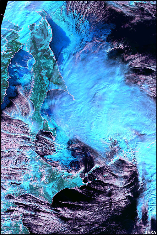
Color image (*) of the area around the Sea of Okhotsk on January 29, 2018, taken by SHIKISAI. Drift ice approaching Japan over the Sea of Okhotsk (© JAXA)
*: SGLI SW3 (wavelength 1630 nm), VN11 (868.5 nm), VN8 (673.5 nm) are used for red, green and blue.
When taking care of a sick person, one first pays attention to his or her complexion. If the cheeks are red, the body temperature may be high. Or paleness may be due to reduced blood flow.
The earth is the same. The Earth's changing climate is reflected in the color of the Earth's surface. When snow falls, the surface becomes white. If a cloud is floating, that part also looks white from space.
The surface of the ground turns green if trees and grass grow. The type of green depends on the type of plant. As planktons breed with the rise in sea temperature, the color of the sea surface changes to the color of the plankton. The reddish-brown plankton cause what is known as the red tide. Observing the red tide from space reveals that it is an area where red tide plankton easily breeds.
Or if the wind whips up the sand, you will see the color of the sand from space. By looking from space at the yellow sand flying from the continent in early spring, you can see where the yellow sand originates and how it reaches Japan.
Observing not only human-visible light but also invisible infrared light with a longer wavelength, allows us to know not only the color but also the temperature. Objects emits infrared light of a wavelength corresponding to the temperature. International airports use infrared cameras to detect fever of travelers, but the principle is the same.
Looking at the earth in the infrared will give you an idea of the temperature of the earth's surface and sea level. From space, it is possible to monitor currents, such as warm and cold currents, and how sea ice in the Antarctic and Arctic flows.
Global observation network for global climate change
Of course, it is not enough to just look at the Earth's complexion in order to understand the entire global climate change. SHIKISAI is a satellite paired with SHIZUKU (GCOM-W: launched in May 2012), which investigates the movement of water on the earth. SHIZUKU is a satellite that checks the water content and water vapor on the surface of the earth by observing radio waves called microwaves.
In addition, SHIKISAI and SHIZUKU aim to further understand global climate change by combining them with satellites equipped with various sensors in Japan and overseas. For example, "OCO-2" in the United States, which investigates the distribution of greenhouse gases such as carbon dioxide and methane, and IBUKI in Japan, Cloud Sat, which examines the distribution of clouds, and Riders (radars using laser beams) in the atmosphere. CALYPSO, the satellite co-developed by the United States and France, investigates fine particles (aerosol) and clouds. EarthCARE, which is equipped with four sensors including Cloud Profiling Radar (CPR), is scheduled to be launched during 2019.
What we ultimately want to know using the data obtained from these satellites is the mechanism of how the Earth's climate is changing. Once the mechanism is known, computer simulations can predict how the Earth's climate will change in the future.
In particular, data from SHIKISAI is expected to provide data on the distribution of aerosols suspended in the terrestrial atmosphere. Various factors including greenhouse gases are involved in global warming. Each element has a different way of working. For example, more greenhouse gases will warm the earth, but clouds will reflect the sun, so more will cool the earth. Aerosols, as well as clouds, cool the earth, but so far aerosols on the ground have been more difficult to measure than aerosols on the sea, and no clear data was available. By measuring aerosols on the surface of the earth, SHIKISAI will be able to more accurately simulate global climate change.
In addition, SHIKISAI will provide observation data to industries such as agriculture and fisheries. Use of the data will not be limited to the field of basic science.
SHIKISAI, the satellite that observes the earth's color & temperature
 Larger view
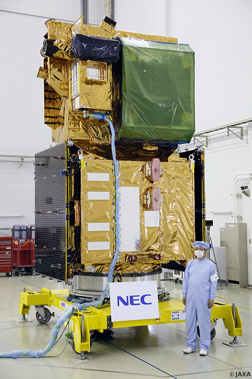
SHIKISAI is an earth observation satellite that examines how the earth's color and temperature are distributed from an orbit that travels from north to south at an altitude of 800 km. Since the Earth rotates eastward, you can see almost all of the Earth's surface from a north-south orbit.
When the solar array paddle is opened, the total width is 16.5m and the satellite weight is about 2 tons. This is the standard size of a Japanese earth observation satellite. The part that carries out the basic functions of the satellite, such as communication, power supply, and attitude control (called a satellite bus), uses a common design with its sibling satellite, SHIZUKU. and SHIKISAI use a common satellite bus, and have different sensors installed. The design life is more than 5 years.
A sensor called multi-wavelength optical radiometer (Second Generation Global Imager or SGLI) examines the color of the earth. This is a further development of the "Global Imager" (GLI) sensor mounted on the previous-generation environmental observation technology satellite Midori 2 (ADEOS-II: launched in 2002). It’s function is to observe visible light and infrared light in 19 wavelength ranges (bands). The SGLI has two light receiving units, a visible / near infrared radiometer (SGLI-VNR) and an infrared scanning radiometer (SGLI-IRS). The SGGLI-VNR observes near ultraviolet via visible light to near infrared, while SGLI-IRS performs observations from short wavelength infrared with longer wavelength using thermal infrared. At some wavelengths, it is possible to measure light that has the same direction of light oscillation as polarized waves. The polarization observation function is expected to be effective in the observation of aerosols on land.
 Larger view
Integrating spheres have perfect uniform surface light source, and by having it detected by sensors in the light receiving elements, the sensitivity difference of each element can be measured. By using the obtained values, you can correct the actual observation data and obtain a uniform observation result.
Since it is a satellite that examines the environment of the entire earth, it does not have the ability to see small objects like an earth observation satellite that examines objects on the surface of the earth. Instead, it is designed to look as broadly as possible at once. This is comparable to the difference between a telephoto lens and a wide-angle lens of a camera. SHIKISAI, which checks the color of the earth, sees the earth with a wide-angle lens. It was designed to focus on observing the exact color over a wide range, as quickly as possible, even if the object’s contours may be vague.
The SHIKISAI SGLI is fine enough to distinguish objects from 250m to 1km in length, and can be observed at a width of 1,150km to 1,400km at a time. It is like capturing the image of a razor shaving the ground between 1,000 km and 1,400 km wide. Since the observations are so wide, SHIKISAI can observe the surface of the entire earth once every two days.
From satellite manufacturing to operation and data processing
NEC has signed a contract with the Japan Aerospace Exploration Agency (JAXA), and has participated in the development of SHIKISAI as the prime company.
In addition to the manufacturing the satellite itself, NEC
-developed and made the SGLI, the on-board sensor that is critical to SHIKISAI
-constructed a unique satellite control system for operating the satellite on the ground
-is responsible for the mission operation system for processing satellites,
-is responsible for the satellite operation support after launch.
The satellite bus is the same as that used by SHIZUKU. However, as the mission and the time when the satellite was manufactured differs, there are some model differences such as the higher accuracy of the attitude control system, faster data transfer speed of the communication system, and replacing batteries that have been discontinued with new ones. Five years have passed since the launch of SHIZUKU, and the design has achieved a lifespan of more than five years, which was the original design goal.
NEC aims to contribute to society through stable and reliable development and operation of satellites.
Translated article originally written by Shinya Matsuura February 28, 2018